Best Things to Do in Big Sur (2026 Guide)
Big Sur is not a town. It is about 90 miles of California coastline where the Santa Lucia Mountains drop straight into the Pacific, and the only road through it is Highway 1. There are no big hotels on every corner, no boardwalk, and long stretches with no gas station and no phone signal. That is exactly why people love it. You drive one of the most beautiful roads in the world, and every few miles there is another cliff, another hidden beach, or another redwood grove that makes you pull over.
The trick with Big Sur is that it rewards slowing down. If you try to race the whole coast in a day, you will spend most of it in the car and remember very little. Pick a handful of stops, give them real time, and let the drive itself be part of the trip. These are the best things to do in Big Sur, in the order you will meet them driving south from Carmel.
Driving Big Sur: North to South
Most people start in Carmel and drive south, and that is the direction this guide follows. Driving south puts you on the ocean side of the road, which means the pullouts are easier to reach and the views open up right beside you. If you are coming from Los Angeles, you can simply read this list in reverse.
A few things to know before you set off. Fill your tank before you enter Big Sur, because gas stations are few and far between and fuel costs more once you are in it. Fog is common, especially in summer mornings, and it can hide the views completely before burning off by midday. Take your time, use the turnouts instead of stopping in the road, and never cross a double yellow line for a photo. The road is narrow, the cliffs are high, and the views are not worth a crash.
The most important warning is about closures. Highway 1 has a long history of landslides, and sections of it close for repairs with little warning. Parts of the parks can close too, after wildfires or storms. Always check the current Highway 1 conditions before you go, and have a backup plan. The same goes for trails: after a recent wildfire in Pfeiffer Big Sur State Park, some trails stayed closed even after the park itself reopened, so check the current trail status rather than assuming everything is open.
If you are spending time in San Francisco before your drive, our guide to the best things to do alone in San Francisco covers the city end of the trip.
Point Lobos State Natural Reserve
Point Lobos sits just south of Carmel, and it is the perfect first stop. People call it the crown jewel of the state park system, and for once the nickname is fair. Short, easy trails loop around cypress groves, sea lion coves, and rocky headlands, and you can see otters, harbor seals, and sometimes whales without hiking for hours.
The Sea Lion Point Trail and the Cypress Grove Trail are both short and flat enough for almost anyone. If you want a longer walk, the loop out to Gibson Beach adds a quiet stretch of sand that most visitors skip. Arrive early, because the parking lot fills up and the reserve turns cars away once it is full. Mornings also give you calmer water and better wildlife spotting.
Garrapata State Beach
Garrapata is easy to miss, and that is part of its charm. There is no big entrance sign, just a series of unmarked gates along the highway leading to different trails and coves. The beach here is wild: rocky shoreline, sandy stretches, sea caves at low tide, and far fewer people than the famous stops further south.
Soberanes Point, at the north end of the park, is a great short walk with big coastal views and a good chance of spotting whales in season. If you are here at sunset, stay for it. The light on the cliffs at Garrapata is some of the best on the whole coast, and the crowds thin out fast in the evening.
Bixby Creek Bridge
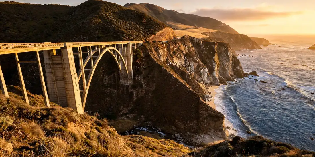
You already know this bridge, even if you have never been here. Bixby Creek Bridge is one of the most photographed bridges in California, a graceful concrete arch spanning a deep canyon with the ocean behind it. The best photos come from the pullout on the north side, looking south across the arch.
It is also one of the busiest stops in Big Sur, so go early or late in the day. Do not stop in the middle of the road or on the bridge itself. Use the dirt pullouts, watch for traffic when you get out of the car, and take your photo quickly. The bridge is beautiful, but it is still a working road, and cars come around the bends fast.
Hurricane Point
Just south of Bixby, Hurricane Point is the highest unobstructed viewpoint on this stretch of coast, and the panorama is enormous. On a clear day you can see the coastline curving away in both directions, and it is one of the best places to understand just how rugged Big Sur really is.
It is also genuinely windy, which is how it got its name. Hold on to your hat, keep a firm grip on your camera, and do not get too close to the unfenced cliff edges. This is a quick stop, ten or fifteen minutes, but it is worth every second on a clear day.
Point Sur Lighthouse
Point Sur is the big volcanic rock rising out of the ocean just off the highway, with a lighthouse on top that has guided ships since the late 1800s. You cannot just walk up to it. The lighthouse is only open on guided tours, which run on set days, so check the schedule before you build your day around it.
Even if you skip the tour, the rock itself is worth a stop. The view from the roadside pullout, with the waves breaking against the rock and the lighthouse standing above them, is one of the classic Big Sur sights. It is also a good reminder of why this coast was so dangerous for ships before the lighthouse was built.
Pfeiffer Beach and Keyhole Arch
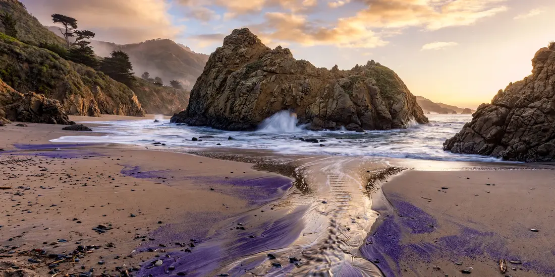
Pfeiffer Beach is the most unusual beach in Big Sur. The sand here has a purple tint from the minerals washing down from the hills, and the star of the show is Keyhole Arch, a rock formation with a natural doorway in it that the waves crash through. At sunset in winter, the light shines right through the arch, and photographers line up for it.
Getting here is part of the adventure. The turnoff is unmarked, down a narrow winding road that is easy to miss, and the small parking lot fills up fast. Go early, drive slowly on the access road, and wear shoes you can walk in, because the path from the lot to the beach is sandy and uneven. Swimming here is not a good idea. The currents are strong and the water is cold, but for walking, photos, and just staring at the ocean, it is hard to beat.
Pfeiffer Big Sur State Park
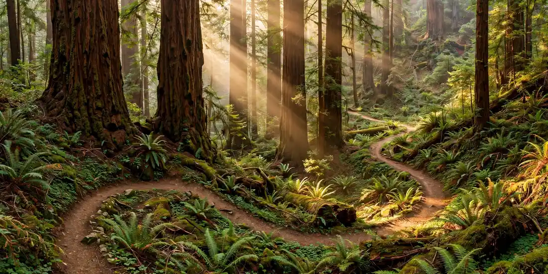
If you want redwoods, this is your stop. Pfeiffer Big Sur State Park sits in a valley along the Big Sur River, and its groves of old coast redwoods feel like a different world from the cliffs outside. The Redwood Deck and the nature center are easy to reach, and the short walks through the grove are perfect if you are traveling with kids or just want a shady break from the sun.
The longer trails here, like the Pfeiffer Falls Trail and the Valley View Trail, climb up through the forest for bigger views, but check their status before you go. After a recent wildfire, some trails in this park stayed closed for safety even after the rest of the park reopened, and conditions change as repairs continue. The campground here is also one of the most popular places to stay in Big Sur, so book well ahead if you want a site.
Nepenthe and Big Sur Dining
Big Sur is not a food destination in the usual sense, because there are only a handful of restaurants, but the ones that exist are memorable. Nepenthe is the famous one: a terrace restaurant perched high above the ocean, built on land once owned by Orson Welles and Rita Hayworth, where you sit under the trees and watch the fog roll in over the Pacific. The food is simple and good, and honestly, you are paying for the view as much as the meal. Go for lunch rather than dinner if you want the best light, and expect a wait at busy times.
Below Nepenthe, the Phoenix Shop sells local art and books, and it is worth a browse. Elsewhere along the coast, the Big Sur Bakery is a local favorite for breakfast and wood fired bread, and the Big Sur Lodge restaurant inside the state park is a reliable, casual option. The practical advice is simple: do not assume you can eat wherever and whenever you want in Big Sur. Options are few, they fill up, and some close early or seasonally. Pack snacks and water for the road, and plan at least one proper meal stop rather than hoping for the best.
Julia Pfeiffer Burns State Park and McWay Falls
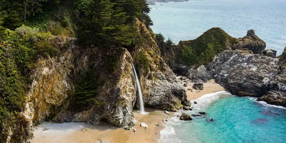
McWay Falls is the postcard image of Big Sur: an 80 foot waterfall dropping off a cliff directly onto a sandy beach. It is one of the only waterfalls in California that falls straight into the ocean, and it is every bit as pretty as the photos suggest.
The good news is that it is also one of the easiest stops. A short, flat trail from the parking lot leads to an overlook above the falls, and you do not need to hike for it. You cannot walk down to the beach itself, because the cove is closed to protect it, but the overlook gives you the full view. Go in the late afternoon if you can, when the light softens and the crowds thin out. And take the extra ten minutes to walk the short Ewoldsen Trail loop above the cove if you want a quieter view of the coast without the crowds at the overlook.
Andrew Molera State Park
Andrew Molera is the largest state park in Big Sur, and it feels wilder and less manicured than the others. A wide meadow leads down to a broad, driftwood covered beach, and the bluff trails above it give you long, empty coastal views. It is a great place for a picnic, and because the parking lot is a little further from the highway than most, it never feels as crowded as the famous stops.
The Bluffs Trail is an easy walk with constant ocean views, while the Panorama Trail climbs higher for a bigger payoff if you have the energy. The park also has a walk in campground and a small museum at the old Molera Ranch House, which is open on a limited schedule. If you want one place in Big Sur where you can slow down and feel like you have the coast to yourself, this is it.
St. Lucia Travel Guide: Everything You Need to Know Before You Go
Limekiln State Park and the Wild South
Limekiln State Park, further south, packs a lot into a small space: redwood forest, a creek, a small beach, and a waterfall at the end of the Limekiln Falls Trail. The trail is short and mostly flat, and walking through redwoods to a waterfall with the ocean nearby feels like Big Sur in miniature.
South of Limekiln, the coast gets wilder and emptier. Sand Dollar Beach is the largest unbroken stretch of sand in Big Sur and a good place to stop if you want a real beach walk. Ragged Point, near the southern end, has a clifftop viewpoint, a restaurant, and a small inn, and it makes a natural last stop before the road turns inland toward San Simeon. If you keep going south, the elephant seal colony at Piedras Blancas is a short detour and one of the best wildlife stops on the whole California coast.
Hiking in Big Sur by Difficulty
Big Sur has hikes for every level, but the terrain is steeper and rougher than it looks from the road, so pick honestly.
For easy walks, start with the McWay Falls overlook, the Cypress Grove Trail at Point Lobos, the Bluffs Trail at Andrew Molera, and the beach walk at Sand Dollar Beach. These are short, mostly flat, and suitable for kids and casual walkers.
For moderate hikes, try the Pfeiffer Falls Trail when it is open, the Buzzards Roost Trail at Pfeiffer Big Sur for a great valley view, the Soberanes Canyon Trail at Garrapata, and the Limekiln Falls Trail. These involve some climbing and uneven ground, so wear proper shoes and bring water.
For harder hikes, the longer routes in the Ventana Wilderness and the Ewoldsen Trail loop above McWay Falls will test your legs. Some backcountry trails in Big Sur are poorly marked and can be closed after fires or storms, so check conditions, carry a map, and do not rely on phone signal. Tell someone where you are going if you head into the backcountry.
Highway 1 Closures and Safety
This section matters more than any single stop, because Big Sur can be dangerous if you treat it like an ordinary road trip. Highway 1 closes, sometimes for months, when landslides take out sections of the road. There is no alternate coastal route. The only detour is the inland Nacimiento-Fergusson Road, which is narrow, winding, and not a shortcut.
Check the highway status before you leave and again the morning you drive. Fog can cut visibility to almost nothing, especially in summer, so slow down and use your lights. Do not stop in the travel lanes for photos, ever. Use the paved turnouts, and if a turnout is full, drive on to the next one. Phone signal comes and goes, so download your maps offline before you go. And remember that help is far away in Big Sur. Carry water, snacks, a first aid kit, and a charged phone, and let someone know your plans if you are hiking alone.
Where to Stay in Big Sur
Big Sur has no big resort strip, and that is the point. Your choices are roughly three kinds: lodges and inns, campgrounds, and a small number of luxury retreats tucked into the hills. Big Sur Lodge, inside Pfeiffer Big Sur State Park, is a solid mid range choice right in the middle of everything. The campgrounds at Pfeiffer Big Sur, Andrew Molera, and Limekiln are beautiful but book out fast, so reserve as early as you can. At the luxury end, there are famous cliffside retreats with ocean views and high prices to match, and they book out months ahead.
If everything in Big Sur is full, Carmel and Monterey to the north and Cambria and San Simeon to the south are all easy bases, and you can drive into Big Sur for the day. Staying outside Big Sur also gives you more restaurants and cheaper gas, which is worth weighing against the magic of waking up in the middle of the coast.
A 1 to 2 Day Big Sur Itinerary
If you only have one day, start in Carmel and drive south. Stop at Point Lobos first thing in the morning, then Garrapata and Bixby Creek Bridge. Have lunch at Nepenthe, then see McWay Falls in the afternoon and finish with Pfeiffer Beach before driving back or continuing south. It is a full day, but it covers the icons without rushing every single stop.
With two days, slow everything down. Day one: Point Lobos, Garrapata, Bixby, Hurricane Point, and Point Sur, then an afternoon hike at Andrew Molera and dinner in the Big Sur valley. Stay overnight in Big Sur. Day two: Pfeiffer Beach in the morning light, redwoods at Pfeiffer Big Sur, lunch at Nepenthe, McWay Falls, and Limekiln Falls on the way south, ending at Sand Dollar Beach or Ragged Point. Two days is the sweet spot. You see everything that matters, and you actually enjoy it instead of collecting photos from the car window.
FAQs About the Best Things to Do in Big Sur
Here are the answers to the questions travelers ask most about visiting Big Sur.
What is the best time of year to visit Big Sur?
Spring and fall are the sweet spots. Spring brings wildflowers and full waterfalls, and fall brings clearer skies and fewer crowds. Summer has the best weather inland but the most fog and the most traffic on the coast. Winter is quiet and dramatic, with big waves and green hills, but storms can close the road, so check conditions before a winter trip.
How long do you need in Big Sur?
One day covers the icons if you start early, but two days is much better. With two days you can hike properly, eat without rushing, and wait out the fog instead of driving through it. If you want to add Hearst Castle or the elephant seals to the south, plan three days.
Is Highway 1 through Big Sur open right now?
It changes, and that is why you have to check. Landslides and construction close sections of Highway 1 regularly, and the closure points move as repairs progress. Check the current highway conditions on the morning of your drive, and do not trust a guidebook or an old blog post, including this one, for road status.
Can you do Big Sur without a car?
Honestly, not well. There is no public bus that runs the full Big Sur coast, and the stops are spread out along 90 miles of highway. A car is essential for a proper Big Sur trip. If you cannot drive, a guided tour from Monterey or Carmel is the best option, and several companies run day trips along the coast.
Do you need reservations for Big Sur?
You do not need reservations to drive Highway 1 or to stop at the viewpoints, but you do need them for campgrounds and popular lodges, which book out well in advance. Point Sur Lighthouse tours run on a schedule, so check that ahead of time. State park parking lots fill up on weekends, so arrive early rather than hoping for a space.
Is Big Sur good for families?
Yes, with some planning. Kids love the beaches, the redwoods, and the wildlife, and the short trails at Point Lobos, McWay Falls, and Limekiln are all family friendly. But the cliffs are unfenced in many places, the ocean currents are dangerous for swimming, and the drives are long and winding, so keep a close eye on children near cliff edges and plan plenty of stops.
Final Thoughts
Big Sur is not a place you conquer. It is a place you drive slowly, stop often, and let surprise you. The famous stops deserve their fame. Bixby Creek Bridge really does look like that. McWay Falls really does drop straight into the ocean. But the moments you will remember most are just as likely to be the unplanned ones: fog lifting off the cliffs at Garrapata, an otter floating past at Point Lobos, or a quiet stretch of beach at Andrew Molera where you are the only person in sight.
That is why the best advice for Big Sur is simple. Do not try to see everything. Pick the stops that excite you, give them real time, check the road before you go, and leave room in your day for the pullout you did not plan. Big Sur has been making travelers slow down for generations, and if you let it, it will do the same for you. Come for the icons, stay for the quiet in between, and you will understand why this stretch of coast has inspired writers, photographers, and wanderers for so long.